
Carte topographique Bexiga
Carte interactive
Cliquez sur la carte pour afficher l’altitude.
À propos de cette carte
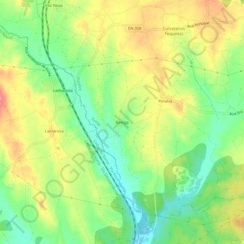
Nom : Carte topographique Bexiga, altitude, relief.
Lieu : Bexiga, Paialvo, Tomar, Santarém, 2305-518, Portugal (39.50266 -8.47634 39.54266 -8.43634)
Altitude moyenne : 80 m
Altitude minimum : 44 m
Altitude maximum : 119 m
Autres cartes topographiques
Cliquez sur une carte pour visualiser sa topographie, son altitude et son relief.
Mata Nacional dos Sete Montes
Portugal > Santarém > Tomar > Casal dos Peixinhos
Mata Nacional dos Sete Montes, Casal dos Peixinhos, Tomar (São João Baptista) e Santa Maria dos Olivais, Tomar, Santarém, 2300-551, Portugal
Altitude moyenne : 102 m
Casais e Alviobeira
Casais e Alviobeira, Tomar, Santarém, Portugal
Altitude moyenne : 181 m
Fonte São Miguel
Fonte São Miguel, Carregueiros, Tomar, Santarém, 2305-176, Portugal
Altitude moyenne : 162 m