
Carte topographique East Greenwich
Carte interactive
Cliquez sur la carte pour afficher l’altitude.
À propos de cette carte
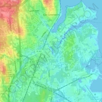
Nom : Carte topographique East Greenwich, altitude, relief.
Altitude moyenne : 21 m
Altitude minimum : -6 m
Altitude maximum : 86 m
Autres cartes topographiques
Cliquez sur une carte pour visualiser sa topographie, son altitude et son relief.
Anthony
United States > Rhode Island > Kent County > Coventry
Anthony, Coventry, Kent County, Rhode Island, 02816, United States
Altitude moyenne : 71 m
Coventry
United States > Rhode Island > Kent County
Coventry, Kent County, Rhode Island, United States
Altitude moyenne : 126 m
Apponaug
United States > Rhode Island > Kent County
Apponaug, Kent County, Rhode Island, 02886, United States
Altitude moyenne : 23 m
Crompton
United States > Rhode Island > Kent County > West Warwick
Crompton, West Warwick, Kent County, Rhode Island, 02893, United States
Altitude moyenne : 63 m
West Greenwich
United States > Rhode Island > Kent County > West Greenwich
West Greenwich, Kent County, Rhode Island, 02817, United States
Altitude moyenne : 111 m
Warwick
United States > Rhode Island > Kent County
Warwick, Kent County, Rhode Island, United States
Altitude moyenne : 34 m