
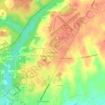
Carte topographique Arrowwood
Carte interactive
Cliquez sur la carte pour afficher l’altitude.
À propos de cette carte
Nom : Carte topographique Arrowwood, altitude, relief.
Altitude moyenne : 74 m
Altitude minimum : 44 m
Altitude maximum : 94 m
Autres cartes topographiques
Cliquez sur une carte pour visualiser sa topographie, son altitude et son relief.
Lockhart Oil Field
United States > South Carolina > Kershaw County
Lockhart Oil Field, Kershaw County, South Carolina, United States
Altitude moyenne : 126 m
White Hills
United States > South Carolina > Kershaw County > Elgin
White Hills, Elgin, Kershaw County, South Carolina, United States
Altitude moyenne : 97 m
Lugoff
United States > South Carolina > Kershaw County
Lugoff, Kershaw County, South Carolina, United States
Altitude moyenne : 69 m
Camden
United States > South Carolina > Kershaw County
Camden, Kershaw County, South Carolina, United States
Altitude moyenne : 68 m
Lake Wateree
United States > South Carolina > Kershaw County
Lake Wateree, Kershaw County, South Carolina, United States
Altitude moyenne : 109 m
Lake Wateree
United States > South Carolina > Kershaw County
Lake Wateree, Kershaw County, South Carolina, United States
Altitude moyenne : 76 m
Woodland Forest
United States > South Carolina > Kershaw County > Lugoff
Woodland Forest, Lugoff, Kershaw County, South Carolina, 29078, United States
Altitude moyenne : 65 m
Green Valley
United States > South Carolina > Kershaw County > Green Valley
Green Valley, Kershaw County, South Carolina, United States
Altitude moyenne : 59 m