
Carte topographique Twin Oaks
Carte interactive
Cliquez sur la carte pour afficher l’altitude.
À propos de cette carte
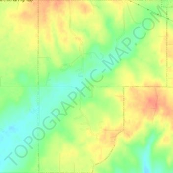
Nom : Carte topographique Twin Oaks, altitude, relief.
Lieu : Twin Oaks, Delaware County, Oklahoma, United States (36.17617 -94.83320 36.20522 -94.80637)
Altitude moyenne : 341 m
Altitude minimum : 315 m
Altitude maximum : 364 m
Autres cartes topographiques
Cliquez sur une carte pour visualiser sa topographie, son altitude et son relief.
Kansas
United States > Oklahoma > Delaware County
Kansas, Delaware County, Oklahoma, United States
Altitude moyenne : 354 m
Eucha
United States > Oklahoma > Delaware County > Eucha
Eucha, Delaware County, Oklahoma, United States
Altitude moyenne : 312 m
Jay
United States > Oklahoma > Delaware County > Jay
Jay, Delaware County, Oklahoma, United States
Altitude moyenne : 306 m
Colcord
United States > Oklahoma > Delaware County > Colcord
Colcord, Delaware County, Oklahoma, United States
Altitude moyenne : 347 m