
Carte topographique Prior Lake
Carte interactive
Cliquez sur la carte pour afficher l’altitude.
À propos de cette carte
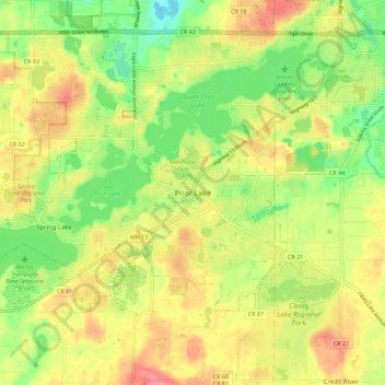
Nom : Carte topographique Prior Lake, altitude, relief.
Lieu : Prior Lake, Scott County, Minnesota, 55372, United States (44.67333 -93.46269 44.75333 -93.38269)
Altitude moyenne : 289 m
Altitude minimum : 247 m
Altitude maximum : 331 m
The eastern portion of Spring Lake along Scott County Road 12 is also located within the City of Prior Lake. Spring Lake, with 290 acres, but being a few minutes further out from the metro area offers similar recreational opportunities as Upper Prior Lake with a more rural character and less traffic. Spring Lake, being several feet higher in elevation, flows north, into Upper Prior Lake via a non-navigable spillway and culvert under County Road 12.