
Carte topographique Dover
Carte interactive
Cliquez sur la carte pour afficher l’altitude.
À propos de cette carte
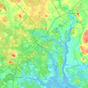
Nom : Carte topographique Dover, altitude, relief.
Lieu : Dover, Strafford County, New Hampshire, 03820, United States (43.11764 -70.96161 43.25498 -70.81902)
Altitude moyenne : 31 m
Altitude minimum : -9 m
Altitude maximum : 106 m
According to the United States Census Bureau, the city has a total area of 29.0 square miles (75.2 km2), of which 26.7 square miles (69.2 km2) are land and 2.3 square miles (6.0 km2) are water, comprising 7.97% of the city. Dover is drained by the Cochecho and Bellamy rivers, both of which flow into the tidal Piscataqua River, which forms the city's eastern boundary and the New Hampshire–Maine border. Long Hill, elevation greater than 300 feet (91 m) above sea level and located 3 miles (5 km) northwest of the city center, is the highest point in Dover. Garrison Hill, elevation approximately 290 ft (88 m), is a prominent hill rising directly above the center city, with a park and lookout tower on top.
Autres cartes topographiques
Cliquez sur une carte pour visualiser sa topographie, son altitude et son relief.
Rollinsford
United States > New Hampshire > Strafford County
Rollinsford, Strafford County, New Hampshire, 03869, United States
Altitude moyenne : 32 m
Somersworth
United States > New Hampshire > Strafford County
Somersworth, Strafford County, New Hampshire, 03878, United States
Altitude moyenne : 56 m
New Durham
United States > New Hampshire > Strafford County
New Durham, Strafford County, New Hampshire, 03855, United States
Altitude moyenne : 228 m
Dover
United States > New Hampshire > Strafford County > Dover
Dover, Strafford County, New Hampshire, 03820, United States
Altitude moyenne : 52 m
Lee
United States > New Hampshire > Strafford County
Lee, Strafford County, New Hampshire, 03861, United States
Altitude moyenne : 47 m
Rochester
United States > New Hampshire > Strafford County > Rochester
Rochester, Strafford County, New Hampshire, United States
Altitude moyenne : 90 m