Carte topographique Redhill
Carte interactive
Cliquez sur la carte pour afficher l’altitude.
À propos de cette carte
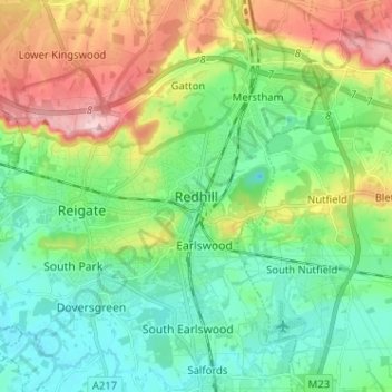
To the north, the town joins with the village of Merstham, north of which there is a "wind gap" in the chalk hills of the North Downs, at an elevation of 120 metres (390 ft) above sea level, through which the A23 road heads in from London. Geologists have speculated that there may once have been a consequent-flowing river, flowing northwards from the centre of the Weald-Artois Anticline and towards the River Thames, which originally cut both the Redhill Gap in the Greensand Ridge and the Merstham Gap in the chalk hills of the North Downs, before its waters were caught by subsequent streams of the River Mole (which itself cuts gaps northwards through the ridge at Betchworth, and through the Downs at Dorking, on its way to the Thames). Today the whole Redhill area is part of the catchment area of the River Mole, and hence the Thames.
Autres cartes topographiques
Cliquez sur une carte pour visualiser sa topographie, son altitude et son relief.
Nork Park
United Kingdom > England > Surrey > Reigate and Banstead > Banstead
Nork Park, Nork, Banstead, Reigate and Banstead, Surrey, England, KT18 5XE, United Kingdom
Altitude moyenne : 143 m
Burgh Heath
United Kingdom > England > Surrey > Reigate and Banstead
Burgh Heath, Reigate and Banstead, Surrey, England, KT20 5NJ, United Kingdom
Altitude moyenne : 143 m
Banstead Wood
United Kingdom > England > Surrey > Reigate and Banstead > Chipstead
Banstead Wood, Chipstead, Reigate and Banstead, Surrey, England, United Kingdom
Altitude moyenne : 145 m
St John's
United Kingdom > England > Surrey > Reigate and Banstead > Redhill
St John's, Meadvale, Redhill, Reigate and Banstead, Surrey, England, RH1 6QD, United Kingdom
Altitude moyenne : 87 m
Reigate
United Kingdom > England > Surrey > Reigate and Banstead
Reigate, Reigate and Banstead, Surrey, England, RH2 0AA, United Kingdom
Altitude moyenne : 100 m
Redhill Common
United Kingdom > England > Surrey > Reigate and Banstead > Redhill
Redhill Common, Meadvale, Redhill, Reigate and Banstead, Surrey, England, United Kingdom
Altitude moyenne : 92 m
Lower Kingswood
United Kingdom > England > Surrey > Reigate and Banstead
Lower Kingswood, Reigate and Banstead, Surrey, England, KT20 7AA, United Kingdom
Altitude moyenne : 170 m
Banstead
United Kingdom > England > Surrey > Reigate and Banstead
Banstead, Reigate and Banstead, Surrey, England, United Kingdom
Altitude moyenne : 142 m
Netherne-on-the-Hill
United Kingdom > England > Surrey > Reigate and Banstead
Netherne-on-the-Hill, Reigate and Banstead, Surrey, England, CR5 1NZ, United Kingdom
Altitude moyenne : 153 m
Reigate Hill
United Kingdom > England > Surrey > Reigate and Banstead
Reigate Hill, Reigate and Banstead, Surrey, England, RH2 9RN, United Kingdom
Altitude moyenne : 157 m
Lower Earlswood Lake
United Kingdom > England > Surrey > Reigate and Banstead > Redhill
Lower Earlswood Lake, Meadvale, Redhill, Reigate and Banstead, Surrey, South East England, England, United Kingdom
Altitude moyenne : 75 m
Salfords
United Kingdom > England > Surrey > Reigate and Banstead
Salfords, Reigate and Banstead, Surrey, England, RH1 5DG, United Kingdom
Altitude moyenne : 64 m
Norwood Hill
United Kingdom > England > Surrey > Reigate and Banstead > Norwood Hill
Norwood Hill, Reigate and Banstead, Surrey, South East England, England, RH6 0ET, United Kingdom
Altitude moyenne : 71 m
Tadworth
United Kingdom > England > Surrey > Reigate and Banstead
Tadworth, Reigate and Banstead, Surrey, England, KT20 5SW, United Kingdom
Altitude moyenne : 159 m
Horley
United Kingdom > England > Surrey > Reigate and Banstead
Horley, Reigate and Banstead, Surrey, England, United Kingdom
Altitude moyenne : 58 m