
Carte topographique Moscow
Carte interactive
Cliquez sur la carte pour afficher l’altitude.
À propos de cette carte
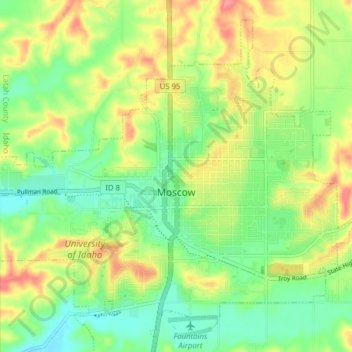
Nom : Carte topographique Moscow, altitude, relief.
Lieu : Moscow, Latah County, Idaho, United States (46.69870 -117.03988 46.75861 -116.96054)
Altitude moyenne : 804 m
Altitude minimum : 765 m
Altitude maximum : 913 m
Along with the rest of the Idaho Panhandle, Moscow is in the Pacific Time Zone. The elevation of its city center is 2,579 feet (786 m) above sea level. Two major highways serve the city, passing through the city center: US-95 (north-south) and ID-8 (east-west). The Pullman–Moscow Regional Airport, four miles (6 km) west, provides limited commercial air service. The local newspaper is the Moscow-Pullman Daily News.
Autres cartes topographiques
Cliquez sur une carte pour visualiser sa topographie, son altitude et son relief.
Juliaetta
United States > Idaho > Latah County
Juliaetta, Latah County, Idaho, 83535, United States
Altitude moyenne : 515 m
Troy
United States > Idaho > Latah County
Troy, Latah County, Idaho, United States
Altitude moyenne : 811 m
Deary
United States > Idaho > Latah County > Deary
Deary, Latah County, Idaho, 88382, United States
Altitude moyenne : 909 m