
Carte topographique Belgorod
Carte interactive
Cliquez sur la carte pour afficher l’altitude.
À propos de cette carte
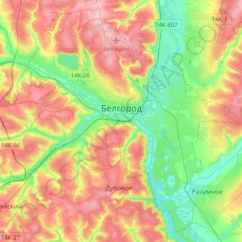
Nom : Carte topographique Belgorod, altitude, relief.
Altitude moyenne : 163 m
Altitude minimum : 107 m
Altitude maximum : 227 m
There were several attacks and incidents reported in Belgorod following the start of the Russian invasion of Ukraine in 2022, during which Belgorod was an important logistics centre for Russian armies. Notably, on 1 April 2022 two Ukrainian Mi-24 performed a night raid and set fire to a fuel depot in Belgorod, in a low-altitude airstrike. On 20 April 2023, a Russian Su-34 fighter jet accidentally dropped a bomb on the city, leaving a crater 20 metres (66 ft) across and injuring two people. On 22 April, more than 3,000 people were evacuated from their homes after an undetonated explosive was found; it was not known if the second bomb had come from the same aircraft.
Autres cartes topographiques
Cliquez sur une carte pour visualiser sa topographie, son altitude et son relief.
Shchetinovka
Russia > Belgorod Oblast > Belgorodsky District
Shchetinovka, Щетиновское сельское поселение, Belgorodsky District, Belgorod Oblast, Central Federal District, Russia
Altitude moyenne : 183 m