
Carte topographique Norman
Carte interactive
Cliquez sur la carte pour afficher l’altitude.
À propos de cette carte
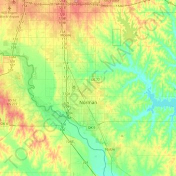
Nom : Carte topographique Norman, altitude, relief.
Lieu : Norman, Cleveland County, Oklahoma, United States (35.14532 -97.54745 35.34832 -97.17692)
Altitude moyenne : 358 m
Altitude minimum : 317 m
Altitude maximum : 432 m
Norman and the surrounding areas are mostly flat with an elevation near 1,171 ft (357 m). The terrain in the western section of Norman is prairie, while the eastern section, including the area surrounding Lake Thunderbird, consists of some 6,000 acres (24 km2) of lakes and Cross Timbers forest. The lowest point within city limits is approximately 970 ft (296 m) above sea level (located at 35.20388N, 97.17735W). The highest point is approximately 1,245 ft (379 m) above sea level (located at 35.21266N, 97.39000W).
Autres cartes topographiques
Cliquez sur une carte pour visualiser sa topographie, son altitude et son relief.
Tom London Dam
United States > Oklahoma > Cleveland County
Tom London Dam, Cleveland County, Oklahoma, United States
Altitude moyenne : 324 m
Little Axe
United States > Oklahoma > Cleveland County > Norman
Little Axe, Norman, Cleveland County, Oklahoma, United States
Altitude moyenne : 321 m
Norman
United States > Oklahoma > Cleveland County > Norman
Norman, Cleveland County, Oklahoma, 73069, United States
Altitude moyenne : 356 m
Moore
United States > Oklahoma > Cleveland County > Moore > Moore
Moore, Cleveland County, Oklahoma, 73160, United States
Altitude moyenne : 377 m