
Faire un don
Équipez-vous pour votre prochaine aventure :
En tant que Partenaire Amazon, ce site perçoit une commission sur les achats éligibles sans surcoût pour vous.
Carte topographique Contagem
Cliquez sur la carte pour afficher l’altitude.
Faire un don
Équipez-vous pour votre prochaine aventure :
En tant que Partenaire Amazon, ce site perçoit une commission sur les achats éligibles sans surcoût pour vous.
Contagem
The city belongs to the metropolitan mesoregion and to the microregion of Belo Horizonte, has a territorial extension of 195.2 square kilometres (75.4 square miles), and borders the municipalities of Ribeirão das Neves, Esmeraldas, Betim, Ibirité and Belo Horizonte. The elevation of the city hall is 939 metres (3,081 feet).
Faire un don
Équipez-vous pour votre prochaine aventure :
En tant que Partenaire Amazon, ce site perçoit une commission sur les achats éligibles sans surcoût pour vous.
À propos de cette carte
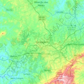
Nom : Carte topographique Contagem, altitude, relief.
Altitude moyenne : 890 m
Altitude minimum : 711 m
Altitude maximum : 1’508 m
Faire un don
Équipez-vous pour votre prochaine aventure :
En tant que Partenaire Amazon, ce site perçoit une commission sur les achats éligibles sans surcoût pour vous.
Autres cartes topographiques
Cliquez sur une carte pour visualiser sa topographie, son altitude et son relief.
Parque Industrial
Brazil > Minas Gerais > Região Metropolitana de Belo Horizonte > Contagem
Altitude moyenne : 942 m
Vila Beneves
Brazil > Minas Gerais > Região Metropolitana de Belo Horizonte > Contagem
Altitude moyenne : 897 m
Nova Contagem
Brazil > Minas Gerais > Região Metropolitana de Belo Horizonte > Contagem
Altitude moyenne : 907 m