
Carte topographique Illmensee
Carte interactive
Cliquez sur la carte pour afficher l’altitude.
Illmensee
The municipality (Gemeinde) of Illmensee is situated at the southeastern corner of the district of Sigmaringen, in the German state of Baden-Württemberg. Illmensee lies along Sigmaringen's border with the district of Ravensburg to the east and the Bodensee district to the south. The municipality is physically located in a depression formed by the Würm glaciation in the Upper Swabian hill country [de]. The municipality's three lakes, the Illmensee itself, Ruschweiler [de], and the Volzer [de] lakes, are glacial lakes that were also formed by the Würm glaciation. Elevation above sea level in the municipal area ranges from a high of 833 meters (2,733 ft) Normalnull (NN) to a low of 667 meters (2,188 ft) NN.
À propos de cette carte
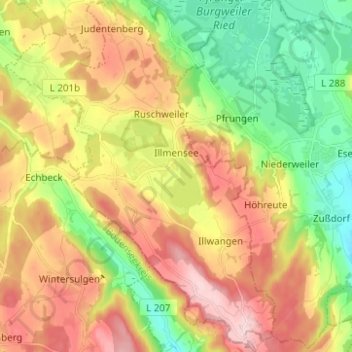
Nom : Carte topographique Illmensee, altitude, relief.
Altitude moyenne : 698 m
Altitude minimum : 577 m
Altitude maximum : 839 m
Autres cartes topographiques
Cliquez sur une carte pour visualiser sa topographie, son altitude et son relief.