
Carte topographique Borgloon
Carte interactive
Cliquez sur la carte pour afficher l’altitude.
À propos de cette carte
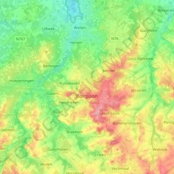
Nom : Carte topographique Borgloon, altitude, relief.
Lieu : Borgloon, Tongeren, Limburg, Flanders, 3840, Belgium (50.76946 5.25038 50.84543 5.40764)
Altitude moyenne : 72 m
Altitude minimum : 33 m
Altitude maximum : 126 m
Autres cartes topographiques
Cliquez sur une carte pour visualiser sa topographie, son altitude et son relief.
Maasmechelen
Belgium > Limburg > Tongeren > Mechelen-aan-de-Maas > Maasmechelen
Maasmechelen, Mechelen-aan-de-Maas, Maasmechelen, Tongeren, Limburg, Flanders, 3630, Belgium
Altitude moyenne : 48 m
Mettekoven
Mettekoven, Heers, Tongeren, Limburg, Flanders, Belgium
Altitude moyenne : 74 m
Maasmechelen
Maasmechelen, Tongeren, Limburg, Flanders, Belgium
Altitude moyenne : 57 m
Alt-Hoeselt
Belgium > Limburg > Tongeren > Hoeselt
Alt-Hoeselt, Hoeselt, Tongeren, Limburg, 3730, Belgium
Altitude moyenne : 85 m