
Carte topographique Hinterweidenthal
Carte interactive
Cliquez sur la carte pour afficher l’altitude.
À propos de cette carte
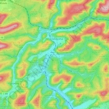
Nom : Carte topographique Hinterweidenthal, altitude, relief.
Altitude moyenne : 294 m
Altitude minimum : 201 m
Altitude maximum : 437 m
Autres cartes topographiques
Cliquez sur une carte pour visualiser sa topographie, son altitude et son relief.
Monbijou
Germany > Rhineland-Palatinate > Südwestpfalz > Dietrichingen
Monbijou, Dietrichingen, Zweibrücken-Land, Südwestpfalz, Rhineland-Palatinate, 66500, Germany
Altitude moyenne : 291 m