

Carte topographique The Alps
Cliquez sur la carte pour afficher l’altitude.
À propos de cette carte
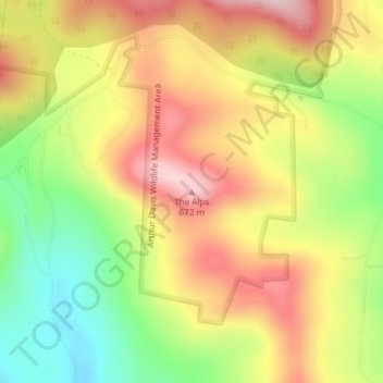
Nom : Carte topographique The Alps, altitude, relief.
Lieu : The Alps, Windsor County, Vermont, United States (43.47502 -72.63820 43.47512 -72.63810)
Altitude moyenne : 551 m
Altitude minimum : 419 m
Altitude maximum : 670 m
Autres cartes topographiques
Cliquez sur une carte pour visualiser sa topographie, son altitude et son relief.
Norwich
United States > Vermont > Windsor County
The landscape is hilly and wooded. The elevation of the town center is 531 feet (162 m). The hills in the town include the 1,700-foot (520 m) Griggs Mountain in the southwestern section and the 1,853-foot (565 m) Gile Mountain in the northwestern section.
Altitude moyenne : 289 m


Proctorsville
United States > Vermont > Windsor County > Cavendish > Proctorsville
Altitude moyenne : 355 m


White River Junction
United States > Vermont > Windsor County > Hartford > White River Junction
Altitude moyenne : 156 m
White River Junction
United States > Vermont > Windsor County > Hartford > White River Junction
Altitude moyenne : 156 m

West Woodstock
United States > Vermont > Windsor County > Woodstock > West Woodstock
Altitude moyenne : 282 m

Norwich
United States > Vermont > Windsor County
The landscape is hilly and wooded. The elevation of the town center is 531 feet (162 m). The hills in the town include the 1,700-foot (520 m) Griggs Mountain in the southwestern section and the 1,853-foot (565 m) Gile Mountain in the northwestern section.
Altitude moyenne : 289 m

West Windsor
United States > Vermont > Windsor County
The unincorporated village of Brownsville is one of the few urban areas in the town and sits at the northwestern base of Mount Ascutney (elevation 3143 ft.).
Altitude moyenne : 366 m
White River Junction
United States > Vermont > Windsor County > Hartford > White River Junction
Altitude moyenne : 156 m

North Springfield
United States > Vermont > Windsor County > Springfield
North Springfield is an unincorporated community and census-designated place in the town of Springfield, Windsor County, Vermont, United States. As of the 2010 census, the population of the CDP was 573. It lies at an altitude of 495 feet (151 m). A post office has been operated in North Springfield since 1832.…
Altitude moyenne : 179 m