
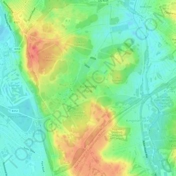
Carte topographique Richmond Park
Carte interactive
Cliquez sur la carte pour afficher l’altitude.
À propos de cette carte
Nom : Carte topographique Richmond Park, altitude, relief.
Altitude moyenne : 26 m
Altitude minimum : 3 m
Altitude maximum : 63 m
Autres cartes topographiques
Cliquez sur une carte pour visualiser sa topographie, son altitude et son relief.
Islington
United Kingdom > England > London
Islington, London, Greater London, England, N1 2SJ, United Kingdom
Altitude moyenne : 30 m
Walthamstow
United Kingdom > England > London > Walthamstow
Walthamstow, London, Greater London, England, E17 3AL, United Kingdom
Altitude moyenne : 21 m
London
United Kingdom > England > London
London, Greater London, England, SW1A 2DX, United Kingdom
Altitude moyenne : 42 m
Croydon
United Kingdom > England > London > Croydon
Croydon, London, Greater London, England, CR0 1SZ, United Kingdom
Altitude moyenne : 70 m
Stevenage
United Kingdom > England > London > Stevenage
Stevenage, London, Hertfordshire, East of England, England, United Kingdom
Altitude moyenne : 108 m
Surrey
United Kingdom > England > London
Surrey, Este Road, Clapham Junction, London Borough of Wandsworth, London, Greater London, England, SW11 2TB, United Kingdom
Altitude moyenne : 69 m
London
United Kingdom > England > London
Royal Borough of Kensington and Chelsea, London, Greater London, England, United Kingdom
Altitude moyenne : 18 m