
Carte topographique McMinnville
Carte interactive
Cliquez sur la carte pour afficher l’altitude.
À propos de cette carte
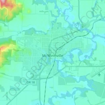
Nom : Carte topographique McMinnville, altitude, relief.
Lieu : McMinnville, Yamhill County, Oregon, 97128, United States (45.18565 -123.25450 45.23922 -123.12920)
Altitude moyenne : 50 m
Altitude minimum : 25 m
Altitude maximum : 254 m
Autres cartes topographiques
Cliquez sur une carte pour visualiser sa topographie, son altitude et son relief.
Newberg
United States > Oregon > Yamhill County
Newberg, Yamhill County, Oregon, United States
Altitude moyenne : 61 m
Sheridan
United States > Oregon > Yamhill County
Sheridan, Yamhill County, Oregon, United States
Altitude moyenne : 85 m
Lafayette
United States > Oregon > Yamhill County
Lafayette, Yamhill County, Oregon, 97127, United States
Altitude moyenne : 52 m
McGuire Reservoir
United States > Oregon > Yamhill County
McGuire Reservoir, Yamhill County, Oregon, United States
Altitude moyenne : 582 m
Bald Peak State Scenic Viewpoint
United States > Oregon > Yamhill County
Bald Peak State Scenic Viewpoint, Southwest Bald Peak Road, Yamhill County, Oregon, United States
Altitude moyenne : 334 m
Carlton
United States > Oregon > Yamhill County
Carlton, Yamhill County, Oregon, 97111, United States
Altitude moyenne : 51 m
Amity
United States > Oregon > Yamhill County
Amity, Yamhill County, Oregon, United States
Altitude moyenne : 51 m
Dayton
United States > Oregon > Yamhill County
Dayton, Yamhill County, Oregon, United States
Altitude moyenne : 43 m
Dundee
United States > Oregon > Yamhill County
Dundee, Yamhill County, Oregon, 97115, United States
Altitude moyenne : 69 m
Willamina
United States > Oregon > Yamhill County > Willamina
Willamina, Yamhill County, Oregon, United States
Altitude moyenne : 93 m
Yamhill
United States > Oregon > Yamhill County > Yamhill
Yamhill, Yamhill County, Oregon, United States
Altitude moyenne : 55 m
Tetons
United States > Oregon > Yamhill County
Tetons, Yamhill County, Oregon, United States
Altitude moyenne : 406 m