
Carte topographique Hopedale
Carte interactive
Cliquez sur la carte pour afficher l’altitude.
À propos de cette carte
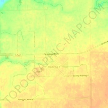
Nom : Carte topographique Hopedale, altitude, relief.
Lieu : Hopedale, Tazewell County, Illinois, United States (40.41767 -89.44817 40.43223 -89.40221)
Altitude moyenne : 195 m
Altitude minimum : 168 m
Altitude maximum : 205 m
Autres cartes topographiques
Cliquez sur une carte pour visualiser sa topographie, son altitude et son relief.
North Pekin
United States > Illinois > Tazewell County
North Pekin, Tazewell County, Illinois, United States
Altitude moyenne : 152 m
Washington
United States > Illinois > Tazewell County
Washington, Tazewell County, Illinois, 61571, United States
Altitude moyenne : 236 m
Morton
United States > Illinois > Tazewell County
Morton, Tazewell County, Illinois, 61550, United States
Altitude moyenne : 219 m
Creve Coeur
United States > Illinois > Tazewell County
Creve Coeur, Tazewell County, Illinois, 61610, United States
Altitude moyenne : 185 m
East Peoria
United States > Illinois > Tazewell County
East Peoria, Tazewell County, Illinois, 61611, United States
Altitude moyenne : 176 m
Pekin
United States > Illinois > Tazewell County
Pekin, Tazewell County, Illinois, 61554, United States
Altitude moyenne : 157 m
Minier
United States > Illinois > Tazewell County
Minier, Tazewell County, Illinois, United States
Altitude moyenne : 195 m
Green Valley
United States > Illinois > Tazewell County
Green Valley, Tazewell County, Illinois, United States
Altitude moyenne : 164 m
Mackinaw
United States > Illinois > Tazewell County
Mackinaw, Tazewell County, Illinois, United States
Altitude moyenne : 198 m