Géolocaliser

Carte topographique Crianlarich

Cliquez sur la carte pour afficher l’altitude.

À propos de cette carte

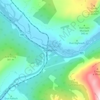
Nom : Carte topographique Crianlarich, altitude, relief.

Lieu : Crianlarich, Stirling, Scotland, FK20 8QN, United Kingdom (56.37263 -4.63589 56.41263 -4.59589)

Altitude moyenne : 289 m

Altitude minimum : 153 m

Altitude maximum : 789 m

Autres cartes topographiques

Cliquez sur une carte pour visualiser sa topographie, son altitude et son relief.

Loch Voil

United Kingdom > Scotland > Stirling > Balquhidder

Altitude moyenne : 370 m

River Teith

United Kingdom > Scotland > Stirling > Callander

Altitude moyenne : 96 m

Loch Arklet

United Kingdom > Scotland > Stirling

Altitude moyenne : 311 m

Loch Venachar

United Kingdom > Scotland > Stirling

Altitude moyenne : 219 m

Loch Lomond

United Kingdom > Scotland > Stirling > Balmaha

Altitude moyenne : 240 m

Loch Lomond and The Trossachs National Park

United Kingdom > Scotland > Stirling

The park straddles the Highland Boundary Fault, which divides it into two distinct regions - lowland and highland - that differ in underlying geology, soil types and topography. The change in rock type can most clearly be seen at Loch Lomond itself, as the fault runs across the islands of Inchmurrin, Creinch,…

Altitude moyenne : 291 m

Loch Lubnaig

United Kingdom > Scotland > Stirling

Altitude moyenne : 382 m

Callander

United Kingdom > Scotland > Stirling

Altitude moyenne : 125 m

Achray Water

United Kingdom > Scotland > Stirling

Altitude moyenne : 167 m

Loch Ardinning

United Kingdom > Scotland > Stirling > Mugdock

Altitude moyenne : 136 m

Abbey Craig

United Kingdom > Scotland > Stirling > Stirling

Altitude moyenne : 16 m

Duchray Water

United Kingdom > Scotland > Stirling

Altitude moyenne : 212 m

Loch Venachar

United Kingdom > Scotland > Stirling

Altitude moyenne : 219 m

Loch Lubnaig

United Kingdom > Scotland > Stirling

Altitude moyenne : 382 m

Killin

United Kingdom > Scotland > Stirling

Altitude moyenne : 174 m

Lake of Menteith

United Kingdom > Scotland > Stirling

Altitude moyenne : 31 m

Loch Ard

United Kingdom > Scotland > Stirling

Altitude moyenne : 154 m

Campsie Fells

United Kingdom > Scotland > Stirling

Altitude moyenne : 156 m

Glen Ogle

United Kingdom > Scotland > Stirling > Lochearnhead

Altitude moyenne : 463 m

Loch Voil

United Kingdom > Scotland > Stirling > Balquhidder

Altitude moyenne : 370 m

Loch Katrine

United Kingdom > Scotland > Stirling

Altitude moyenne : 349 m

Loch Chon

United Kingdom > Scotland > Stirling

Altitude moyenne : 242 m

Loch Doine

United Kingdom > Scotland > Stirling

Altitude moyenne : 301 m

Loch Earn

United Kingdom > Scotland > Stirling > Lochearnhead

Altitude moyenne : 393 m

Doune

United Kingdom > Scotland > Stirling

Altitude moyenne : 48 m

Équipez-vous pour votre prochaine aventure :

🔭Jumelles de randonnée - Compactes et légères pour observer le relief et la faune des Alpes
🦵Guêtres de marche - Empêchent la neige, la boue et les cailloux d'entrer dans vos chaussures
🗻Équipement d’alpinisme - Matériel essentiel haute montagne
🧣Tour de cou multifonction - Protège du froid, du vent ou du soleil selon vos besoins
💧Poche à eau pour sac - Hydratez-vous facilement sans vous arrêter de marcher

En tant que Partenaire Amazon, ce site perçoit une commission sur les achats éligibles sans surcoût pour vous.