
Carte topographique Ashley National Forest
Carte interactive
Cliquez sur la carte pour afficher l’altitude.
À propos de cette carte
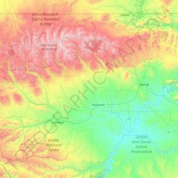
Nom : Carte topographique Ashley National Forest, altitude, relief.
Lieu : Ashley National Forest, Utah, United States of America (39.86976 -111.03895 40.96517 -109.24133)
Altitude moyenne : 2’248 m
Altitude minimum : 1’405 m
Altitude maximum : 4’088 m
Autres cartes topographiques
Cliquez sur une carte pour visualiser sa topographie, son altitude et son relief.
Jackson Hole
United States of America > Utah
Jackson Hole, Grand County, Utah, United States of America
Altitude moyenne : 1’313 m
Wasatch Range
United States of America > Utah > Sandy
Wasatch Range, Sandy, Salt Lake County, Utah, United States of America
Altitude moyenne : 1’880 m
Hyrum
United States of America > Utah > Hyrum
Hyrum, Cache County, Utah, United States of America
Altitude moyenne : 1’442 m
Mount Nebo
United States of America > Utah
Mount Nebo, Juab County, Utah, United States of America
Altitude moyenne : 3’115 m
Towne Center Apartments
United States of America > Utah > Herriman > Towne Center Apartments
Towne Center Apartments, Herriman, Salt Lake County, Utah, 84096, United States of America
Altitude moyenne : 1’467 m
Moon Apartments
United States of America > Utah > Provo > Moon Apartments
Moon Apartments, Provo, Utah County, Utah, 84601, United States of America
Altitude moyenne : 1’421 m
(West) Mueller Park
United States of America > Utah > Bountiful
(West) Mueller Park, Bountiful, Davis County, Utah, United States of America
Altitude moyenne : 1’473 m
Linden Circle
United States of America > Utah > Holladay
Linden Circle, Holladay, Salt Lake County, Utah, 85412, United States of America
Altitude moyenne : 1’365 m
Eddie Kay
United States of America > Utah > Millcreek
Eddie Kay, Millcreek, Salt Lake County, Utah, 84117, United States of America
Altitude moyenne : 1’331 m
Wendover
United States of America > Utah > Wendover
Wendover, Tooele County, Utah, 84083, United States of America
Altitude moyenne : 1’369 m
Salt Point
United States of America > Utah
Salt Point, Emery County, Utah, United States of America
Altitude moyenne : 1’811 m
Twin Peaks
United States of America > Utah > Midvale
Twin Peaks, Midvale, Salt Lake County, Utah, 84107, United States of America
Altitude moyenne : 1’337 m