
Carte topographique Clayton
Carte interactive
Cliquez sur la carte pour afficher l’altitude.
À propos de cette carte
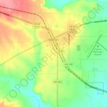
Nom : Carte topographique Clayton, altitude, relief.
Lieu : Clayton, Union County, New Mexico, United States (36.41628 -103.20096 36.46747 -103.11689)
Altitude moyenne : 1’526 m
Altitude minimum : 1’488 m
Altitude maximum : 1’573 m
According to the United States Census Bureau, the town has a total area of 4.7 square miles (12 km2), all land. Clayton has an elevation of approximately 5,050 feet (1,540 m) above sea level. It is located about 130 miles (210 km) northwest of Amarillo, Texas. Clayton is considered to be in the Plains region of New Mexico. This region stretches to the Sangre de Cristo Mountains down to the Guadalupe Mountains. Clayton is located in the northeast corner of New Mexico, 10 miles (16 km) from the border of Texas and 11 miles (18 km) from the border of the Oklahoma panhandle. Clayton is also located near two parks, Clayton Lake State Park, and Capulin Volcano National Monument. Not far away is Black Mesa State Park in Oklahoma. A carbon dioxide field called Bravo Dome can be found near Clayton and stretches nearly 1 million acres.