
Carte topographique Johnstown
Carte interactive
Cliquez sur la carte pour afficher l’altitude.
À propos de cette carte
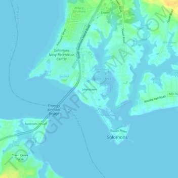
Nom : Carte topographique Johnstown, altitude, relief.
Altitude moyenne : 3 m
Altitude minimum : -7 m
Altitude maximum : 25 m
Autres cartes topographiques
Cliquez sur une carte pour visualiser sa topographie, son altitude et son relief.
Patuxent River
United States > Maryland > Calvert County > Solomons
Patuxent River, Solomons, Calvert County, Maryland, United States
Altitude moyenne : 25 m