
Carte topographique South Salem
Carte interactive
Cliquez sur la carte pour afficher l’altitude.
À propos de cette carte
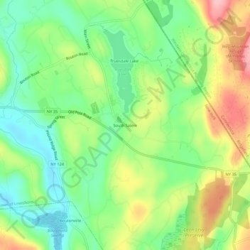
Nom : Carte topographique South Salem, altitude, relief.
Altitude moyenne : 176 m
Altitude minimum : 118 m
Altitude maximum : 263 m
Autres cartes topographiques
Cliquez sur une carte pour visualiser sa topographie, son altitude et son relief.
Goldens Bridge
United States > New York > Westchester County > Town of Lewisboro
Goldens Bridge, Town of Lewisboro, Westchester County, New York, United States
Altitude moyenne : 94 m
Waccabuc
United States > New York > Westchester County > Town of Lewisboro
Waccabuc, Town of Lewisboro, Westchester County, New York, 10597, United States
Altitude moyenne : 183 m