
Carte topographique Buguey
Carte interactive
Cliquez sur la carte pour afficher l’altitude.
À propos de cette carte
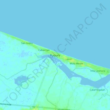
Nom : Carte topographique Buguey, altitude, relief.
Lieu : Buguey, Cagayan, Cagayan Valley, 3511, Philippines (18.24823 121.79213 18.32823 121.87213)
Altitude moyenne : 1 m
Altitude minimum : -4 m
Altitude maximum : 11 m
Autres cartes topographiques
Cliquez sur une carte pour visualiser sa topographie, son altitude et son relief.
Peñablanca
Peñablanca, Cagayan, Cagayan Valley, Philippines
Altitude moyenne : 53 m
Babuyan Claro
Philippines > Cagayan > Calayan
Babuyan Claro, Calayan, Cagayan, Cagayan Valley, Philippines
Altitude moyenne : 182 m
Magapit
Philippines > Cagayan > Lal-lo
Magapit, Lal-lo, Cagayan, Cagayan Valley, 3509, Philippines
Altitude moyenne : 45 m
Divisoria
Divisoria, Cagayan, Cagayan Valley, Philippines
Altitude moyenne : 27 m
Mount Cagua
Mount Cagua, Cagayan, Cagayan Valley, Philippines
Altitude moyenne : 803 m
Dalupiri Island
Philippines > Cagayan > Calayan
Dalupiri Island, Calayan, Cagayan, Cagayan Valley, Philippines
Altitude moyenne : 25 m
Masi
Philippines > Cagayan > Pamplona
Masi, Pamplona, Cagayan, Cagayan Valley, Philippines
Altitude moyenne : 14 m
Santo Niño
Philippines > Cagayan > Claveria
Santo Niño, Claveria, Cagayan, Cagayan Valley, Philippines
Altitude moyenne : 41 m
Baggao
Baggao, Cagayan, Cagayan Valley, 3506, Philippines
Altitude moyenne : 48 m
Solana
Solana, Cagayan, Cagayan Valley, 3503, Philippines
Altitude moyenne : 33 m
Sanchez Mira
Sanchez Mira, Cagayan, Cagayan Valley, 3518, Philippines
Altitude moyenne : 56 m
Tuguegarao
Tuguegarao, Cagayan, Cagayan Valley, 3500, Philippines
Altitude moyenne : 49 m
Carilucud
Carilucud, Cagayan, Cagayan Valley, Philippines
Altitude moyenne : 39 m
Santa Praxedes
Santa Praxedes, Cagayan, Cagayan Valley, 3521, Philippines
Altitude moyenne : 157 m
Bangag
Bangag, Cagayan, Cagayan Valley, 3509, Philippines
Altitude moyenne : 25 m
Fuga Island
Fuga Island, Cagayan, Cagayan Valley, Philippines
Altitude moyenne : 9 m
Santa Maria
Santa Maria, Cagayan, Cagayan Valley, 3519, Philippines
Altitude moyenne : 28 m
Gonzaga
Gonzaga, Cagayan, Cagayan Valley, 3513, Philippines
Altitude moyenne : 38 m
Roma Norte
Roma Norte, Cagayan, Cagayan Valley, Philippines
Altitude moyenne : 53 m
Balzain West
Philippines > Cagayan > Tuguegarao
Balzain West, Tuguegarao, Cagayan, Cagayan Valley, 3500, Philippines
Altitude moyenne : 25 m
Centro
Philippines > Cagayan > Centro
Centro, Cagayan, Cagayan Valley, Philippines
Altitude moyenne : 9 m
Bidduang
Philippines > Cagayan > Bidduang
Bidduang, Cagayan, Cagayan Valley, Philippines
Altitude moyenne : 10 m
Lal-lo
Philippines > Cagayan > Lal-lo
Lal-lo, Cagayan, Cagayan Valley, 3509, Philippines
Altitude moyenne : 18 m
Callao Cave
Callao Cave, Cagayan, Cagayan Valley, 3502, Philippines
Altitude moyenne : 119 m
Gattaran
Philippines > Cagayan > Gattaran
Gattaran, Cagayan, Cagayan Valley, 3508, Philippines
Altitude moyenne : 16 m
Enrile
Philippines > Cagayan > Enrile
Enrile, Cagayan, Cagayan Valley, Philippines
Altitude moyenne : 45 m
Mount Lico
Philippines > Cagayan > Sanchez Mira
Mount Lico, Sanchez Mira, Cagayan, Cagayan Valley, Philippines
Altitude moyenne : 160 m
Chico River
Philippines > Cagayan > Tuguegarao
Chico River, Tuguegarao, Cagayan, Cagayan Valley, 3500, Philippines
Altitude moyenne : 36 m
Tuguegarao
Philippines > Cagayan > Tuguegarao
Tuguegarao, Cagayan, Cagayan Valley, 3500, Philippines
Altitude moyenne : 89 m
Claveria
Claveria, Cagayan, Cagayan Valley, 3519, Philippines
Altitude moyenne : 31 m