
Carte topographique Thornwood
Carte interactive
Cliquez sur la carte pour afficher l’altitude.
À propos de cette carte
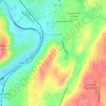
Nom : Carte topographique Thornwood, altitude, relief.
Altitude moyenne : 121 m
Altitude minimum : 73 m
Altitude maximum : 187 m
Autres cartes topographiques
Cliquez sur une carte pour visualiser sa topographie, son altitude et son relief.
Hawthorne
United States > New York > Westchester County > Town of Mount Pleasant
Hawthorne, Town of Mount Pleasant, Westchester County, New York, 10532, United States
Altitude moyenne : 114 m
Valhalla
United States > New York > Westchester County > Town of Mount Pleasant
Valhalla, Town of Mount Pleasant, Westchester County, New York, 10595, United States
Altitude moyenne : 109 m
Village of Sleepy Hollow
United States > New York > Westchester County > Town of Mount Pleasant
Village of Sleepy Hollow, Town of Mount Pleasant, Westchester County, New York, United States
Altitude moyenne : 46 m
Village of Pleasantville
United States > New York > Westchester County > Town of Mount Pleasant
Village of Pleasantville, Town of Mount Pleasant, Westchester County, New York, 10570, United States
Altitude moyenne : 124 m