
Carte topographique Maymana
Carte interactive
Cliquez sur la carte pour afficher l’altitude.
Maymana
Maymana is located at the northern foot of the Torkestan Range at an elevation of 877 m (2,877 ft) on the old terrace of the Qeysar or Maymana River, which is a right tributary of the Murghab River. The Maymana River branches off of the Band-e Turkistan River 50 km south of the city. The highlands of the Maymana region generally possess a very rich topsoil which supports the seasonal agricultural activities.
À propos de cette carte
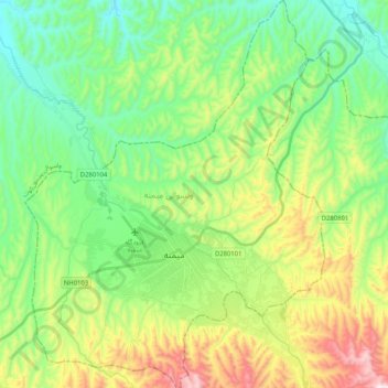
Nom : Carte topographique Maymana, altitude, relief.
Lieu : Maymana, Faryab Province, Afghanistan (35.86355 64.70307 36.02992 64.86199)
Altitude moyenne : 890 m
Altitude minimum : 677 m
Altitude maximum : 1’334 m
Autres cartes topographiques
Cliquez sur une carte pour visualiser sa topographie, son altitude et son relief.