
Carte topographique La Chenal
Carte interactive
Cliquez sur la carte pour afficher l’altitude.
À propos de cette carte
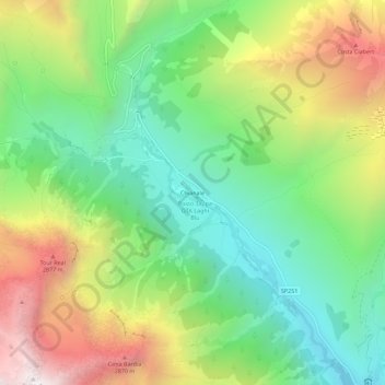
Nom : Carte topographique La Chenal, altitude, relief.
Lieu : La Chenal, Pontechianale, Coni, Piémont, Italie (44.62665 6.97869 44.66665 7.01869)
Altitude moyenne : 2’223 m
Altitude minimum : 1’660 m
Altitude maximum : 3’108 m
Autres cartes topographiques
Cliquez sur une carte pour visualiser sa topographie, son altitude et son relief.
Gr. dell'Agnello
Italie > Piémont > Coni > Pontechianale
Gr. dell'Agnello, Pontechianale, Coni, Piémont, Italie
Altitude moyenne : 2’400 m
Castello
Italie > Piémont > Coni > Pontechianale
Castello, Pontechianale, Coni, Piémont, Italie
Altitude moyenne : 1’901 m
Fonte
Italie > Piémont > Coni > Pontechianale
Fonte, Monviso - via normale, Pontechianale, Coni, Piémont, Italie
Altitude moyenne : 2’690 m
Col Agnel
Italie > Piémont > Coni > Pontechianale
Col Agnel, Pontechianale, Coni, Piémont, Italie
Altitude moyenne : 2’700 m