
Carte topographique Fort Smith
Carte interactive
Cliquez sur la carte pour afficher l’altitude.
À propos de cette carte
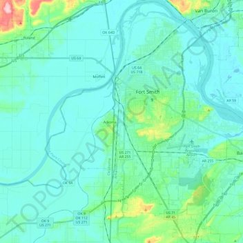
Nom : Carte topographique Fort Smith, altitude, relief.
Lieu : Fort Smith, Sebastian County, Arkansas, United States (35.25885 -94.43554 35.44982 -94.25286)
Altitude moyenne : 140 m
Altitude minimum : 114 m
Altitude maximum : 266 m
The United States acquired the territory and large areas west of the Mississippi River from France in the Louisiana Purchase (1803). Soon after, the government sent the Pike Expedition (1806) to explore the areas along the Arkansas River. The US founded Fort Smith in 1817 as a military post. It was named after General Thomas Adams Smith (1781–1844), who commanded the United States Army Rifle Regiment in 1817, headquartered near St. Louis. General Smith had ordered Army topographical engineer Stephen H. Long (1784–1864) to find a suitable site on the Arkansas River for a fort. General Smith never visited the town or the forts that bore his name.
Autres cartes topographiques
Cliquez sur une carte pour visualiser sa topographie, son altitude et son relief.
Saw Mill
United States > Arkansas > Sebastian County > Fort Smith > Saw Mill
Saw Mill, Fort Smith, Sebastian County, Arkansas, 72916, United States
Altitude moyenne : 167 m