
Carte topographique Anjoman
Carte interactive
Cliquez sur la carte pour afficher l’altitude.
Anjoman
Because of its high altitude, Anjuman enjoys an alpine tundra climate (Köppen climate classification: ET) with short, pleasant summers and long, cold winters. The village lies in the discontinuous permafrost zone, as the average annual temperature reaches −3.2 °C (26.2 °F).
À propos de cette carte
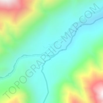
Nom : Carte topographique Anjoman, altitude, relief.
Lieu : Anjoman, Kuran wa Munjan, Badakhshan Province, Afghanistan (35.89098 70.41035 35.89663 70.41752)
Altitude moyenne : 3’280 m
Altitude minimum : 3’006 m
Altitude maximum : 3’975 m
Autres cartes topographiques
Cliquez sur une carte pour visualiser sa topographie, son altitude et son relief.
Koran va Monjan
Afghanistan > Badakhshan Province > Kuran wa Munjan
Owing to its altitude, Kuran wa Munjan features a subarctic climate (Dsc) bordering on a tundra climate (ET) under the Köppen climate classification. It has brief, pleasant summers and very cold, snowy winters. Winters are extremely long with below-freezing months from October until May. Summers are very…
Altitude moyenne : 3’132 m