
Carte topographique Prior Lake
Carte interactive
Cliquez sur la carte pour afficher l’altitude.
À propos de cette carte
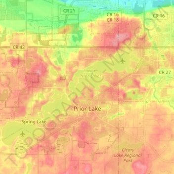
Nom : Carte topographique Prior Lake, altitude, relief.
Lieu : Prior Lake, Scott County, Minnesota, 55372, United States (44.68860 -93.51201 44.76124 -93.37963)
Altitude moyenne : 282 m
Altitude minimum : 220 m
Altitude maximum : 326 m
The eastern portion of Spring Lake along Scott County Road 12 is also located within the City of Prior Lake. Spring Lake, with 290 acres, but being a few minutes further out from the metro area offers similar recreational opportunities as Upper Prior Lake with a more rural character and less traffic. Spring Lake, being several feet higher in elevation, flows north, into Upper Prior Lake via a non-navigable spillway and culvert under County Road 12.
Autres cartes topographiques
Cliquez sur une carte pour visualiser sa topographie, son altitude et son relief.
Eagle Creek
United States > Minnesota > Scott County
Eagle Creek, Scott County, Minnesota, United States
Altitude moyenne : 284 m
Savage
United States > Minnesota > Scott County > Savage > Savage
Savage, Scott County, Minnesota, 55378, United States
Altitude moyenne : 251 m
Shakopee
United States > Minnesota > Scott County > Shakopee > Shakopee
Shakopee, Scott County, Minnesota, 55379, United States
Altitude moyenne : 248 m
Shakopee
United States > Minnesota > Scott County
Shakopee, Scott County, Minnesota, 55379, United States
Altitude moyenne : 257 m
Savage
United States > Minnesota > Scott County
Savage, Scott County, Minnesota, 55378, United States
Altitude moyenne : 262 m