Géolocaliser

Carte topographique Ghost Lake

Cliquez sur la carte pour afficher l’altitude.

À propos de cette carte

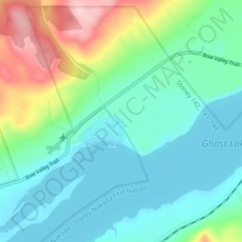
Nom : Carte topographique Ghost Lake, altitude, relief.

Lieu : Ghost Lake, Division No. 15, Alberta, Canada (51.18798 -114.77853 51.22798 -114.73853)

Altitude moyenne : 1’241 m

Altitude minimum : 1’189 m

Altitude maximum : 1’395 m

Autres cartes topographiques

Cliquez sur une carte pour visualiser sa topographie, son altitude et son relief.

Second Lake

Canada > Alberta > Division No. 15 > Municipality of Jasper

Altitude moyenne : 1’155 m

Rawson Lake

Canada > Alberta > Division No. 15

Altitude moyenne : 2’162 m

Chain Lakes Provincial Park

Canada > Alberta > Division No. 15

Altitude moyenne : 1’365 m

Mildred Lake

Canada > Alberta > Division No. 15 > Municipality of Jasper

Altitude moyenne : 1’046 m

Lac des Arcs

Canada > Alberta > Division No. 15 > Lac des Arcs

Altitude moyenne : 1’347 m

Johnston Creek

Canada > Alberta > Division No. 15

Johnston Creek originates north of Castle Mountain in a glacial valley southwest of Badger Pass and south of Pulsatilla Pass, at an elevation of 2,500 meters (8,200 ft). The creek flows southeast between Helena Ridge and the Sawback Range, and then south through a gorge known as Johnston Canyon. The stream…

Altitude moyenne : 2’126 m

Barrier Lake

Canada > Alberta > Division No. 15

Altitude moyenne : 1’571 m

Upper Kananaskis Lake

Canada > Alberta > Division No. 15

Altitude moyenne : 1’775 m

Équipez-vous pour votre prochaine aventure :

🔒Cadenas à code - Sécurisez vos affaires dans les auberges ou les refuges
🧴Crème solaire sport SPF 50 - Résistante à la sueur pour une protection longue durée
🧗Sets de via ferrata - Sécurité sur parcours équipés
🧴Crèmes solaires haute protection - Protection UV renforcée
💧Poche à eau pour sac - Hydratez-vous facilement sans vous arrêter de marcher

En tant que Partenaire Amazon, ce site perçoit une commission sur les achats éligibles sans surcoût pour vous.