
Carte topographique Sequoyah State Park
Carte interactive
Cliquez sur la carte pour afficher l’altitude.
À propos de cette carte
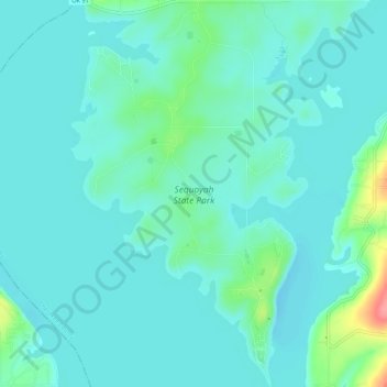
Nom : Carte topographique Sequoyah State Park, altitude, relief.
Lieu : Sequoyah State Park, Cherokee County, Oklahoma, USA (35.88537 -95.26843 35.92965 -95.22599)
Altitude moyenne : 177 m
Altitude minimum : 162 m
Altitude maximum : 247 m
Autres cartes topographiques
Cliquez sur une carte pour visualiser sa topographie, son altitude et son relief.
Sooner Lake
Sooner Lake, Tumbleweed, Noble County, Oklahoma, USA
Altitude moyenne : 286 m
Wichita Mountains Wildlife Refuge
Wichita Mountains Wildlife Refuge, Comanche County, Oklahoma, USA
Altitude moyenne : 592 m
Okmulgee Lake
Okmulgee Lake, South 160 Road, Okmulgee County, Oklahoma, USA
Altitude moyenne : 232 m
Stanley Draper Lake
USA > Oklahoma > Oklahoma City
Stanley Draper Lake, Southeast 104th Street, Oklahoma City, Cleveland County, Oklahoma, 73165, USA
Altitude moyenne : 367 m
Fort Supply Lake
Fort Supply Lake, N1922 Road, Woodward County, Oklahoma, 73802, USA
Altitude moyenne : 625 m
Lake Thunderbird State Park
Lake Thunderbird State Park, Little Axe, Norman, Cleveland County, Oklahoma, 73026, USA
Altitude moyenne : 335 m
Collinsville
USA > Oklahoma > Collinsville
Collinsville, Tulsa County, Oklahoma, 74021, USA
Altitude moyenne : 199 m
Washita Battlefield National Historic Site
Washita Battlefield National Historic Site, Roger Mills County, Oklahoma, USA
Altitude moyenne : 602 m
Lake Humphreys
Lake Humphreys, Area A, Duncan, Stephens County, Oklahoma, USA
Altitude moyenne : 366 m
Lake Lawtonka
USA > Oklahoma > Lawtonka Acres
Lake Lawtonka, Eagle Mountain Road, Lawtonka Acres, Comanche County, Oklahoma, 73557, USA
Altitude moyenne : 428 m
Canadian River
Canadian River, Canadian County, Oklahoma, 74531, USA
Altitude moyenne : 420 m
Wildlife Management Area
Wildlife Management Area, Fugate, Atoka County, Oklahoma, USA
Altitude moyenne : 206 m
Camelback Mountain
Camelback Mountain, Kiowa County, Oklahoma, USA
Altitude moyenne : 449 m
Dahlgren Lake
USA > Oklahoma > McKiddyville
Dahlgren Lake, Duffy Road, McKiddyville, Cleveland County, Oklahoma, 73051, USA
Altitude moyenne : 351 m
Bluestem Lake
Bluestem Lake, CR 4291, Osage County, Oklahoma, USA
Altitude moyenne : 281 m
Sams Point
USA > Oklahoma > Sams Point
Sams Point, Pittsburg County, Oklahoma, USA
Altitude moyenne : 190 m
Fort Cobb Reservoir
Fort Cobb Reservoir, E1250 Road, Swan Lake, Caddo County, Oklahoma, USA
Altitude moyenne : 427 m
Lake of the Arbuckles
Lake of the Arbuckles, Bud Drive, Rayford, Murray County, Oklahoma, USA
Altitude moyenne : 283 m
Alabaster Caverns State Park
Alabaster Caverns State Park, Woodward County, Oklahoma, USA
Altitude moyenne : 518 m
Lake Raymond Gary
USA > Oklahoma > Fort Towson
Lake Raymond Gary, Bluff Street, Fort Towson, Choctaw County, Oklahoma, 74735, USA
Altitude moyenne : 138 m
Clayton Lake
Clayton Lake, US 271, Nashoba Y, Pushmataha County, Oklahoma, 74536, USA
Altitude moyenne : 256 m
Lake Altus
Lake Altus, North Shore Road, Lugert, Kiowa County, Oklahoma, USA
Altitude moyenne : 478 m
Gloss Mountain State Park
Gloss Mountain State Park, Major County, Oklahoma, USA
Altitude moyenne : 418 m
KOMA-AM (Oklahoma City)
KOMA-AM (Oklahoma City), Southwest 4th Street, Moore, Cleveland County, Oklahoma, 73160, USA
Altitude moyenne : 375 m
Centerville
USA > Oklahoma > Centerville
Centerville, Kiowa County, Oklahoma, USA
Altitude moyenne : 434 m
Lake Claremore
Lake Claremore, East 465, Sequoyah, Rogers County, Oklahoma, 74017, USA
Altitude moyenne : 199 m
Lake Jed Johnson
USA > Oklahoma > The Holy City
Lake Jed Johnson, Jed Johnson Tower trail, The Holy City, Comanche County, Oklahoma, USA
Altitude moyenne : 509 m
Lake Yahola
Lake Yahola, East Mohawk Boulevard, Yahola Estates, Tulsa, Tulsa County, Oklahoma, 74115, USA
Altitude moyenne : 187 m
Tulsa Botanic Garden
USA > Oklahoma > Lefko Hill
Tulsa Botanic Garden, Lefko Hill, Osage County, Oklahoma, USA
Altitude moyenne : 268 m
Boggy Creek Watershed Site 13 Reservoir
USA > Oklahoma > Braithwaite
Boggy Creek Watershed Site 13 Reservoir, E1150 Road, Braithwaite, Washita County, Oklahoma, 73624, USA
Altitude moyenne : 523 m
Razorback Mountain
Razorback Mountain, Pushmataha County, Oklahoma, 74557, USA
Altitude moyenne : 231 m