
Carte topographique Bramshaw
Cliquez sur la carte pour afficher l’altitude.
À propos de cette carte
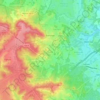
Nom : Carte topographique Bramshaw, altitude, relief.
Lieu : Bramshaw, New Forest, Hampshire, England, United Kingdom (50.90277 -1.69643 50.95925 -1.59009)
Altitude moyenne : 66 m
Altitude minimum : 15 m
Altitude maximum : 133 m
Autres cartes topographiques
Cliquez sur une carte pour visualiser sa topographie, son altitude et son relief.
South Baddesley
United Kingdom > England > Hampshire > New Forest > Norleywood
Altitude moyenne : 13 m
Warwick Slade
United Kingdom > England > Hampshire > New Forest > Lyndhurst > Allum Green
Altitude moyenne : 36 m
Newbridge Inclosure
United Kingdom > England > Hampshire > New Forest > Copythorne
Altitude moyenne : 29 m
Bickton
United Kingdom > England > Hampshire > New Forest > Fordingbridge > Bickton
Altitude moyenne : 39 m
Monkton Mead
United Kingdom > England > Hampshire > New Forest > Breamore > South Charford
Altitude moyenne : 52 m