
Carte topographique Daiyana
Carte interactive
Cliquez sur la carte pour afficher l’altitude.
À propos de cette carte
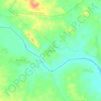
Nom : Carte topographique Daiyana, altitude, relief.
Lieu : Daiyana, Galiakot Tehsil, Dungarpur District, Rajasthan, India (23.60080 73.93532 23.64080 73.97532)
Altitude moyenne : 160 m
Altitude minimum : 138 m
Altitude maximum : 201 m
Autres cartes topographiques
Cliquez sur une carte pour visualiser sa topographie, son altitude et son relief.
Bhemai
India > Rajasthan > Galiakot Tehsil
Bhemai, Galiakot Tehsil, Dungarpur District, Rajasthan, India
Altitude moyenne : 187 m
Nadiya
India > Rajasthan > Galiakot Tehsil
Nadiya, Galiakot Tehsil, Dungarpur District, Rajasthan, India
Altitude moyenne : 148 m
Silohi
India > Rajasthan > Galiakot Tehsil
Silohi, Galiakot Tehsil, Dungarpur District, Rajasthan, 314026, India
Altitude moyenne : 140 m