
Faire un don
Équipez-vous pour votre prochaine aventure :
En tant que Partenaire Amazon, ce site perçoit une commission sur les achats éligibles sans surcoût pour vous.
Carte topographique Koloriang
Cliquez sur la carte pour afficher l’altitude.
Faire un don
Équipez-vous pour votre prochaine aventure :
En tant que Partenaire Amazon, ce site perçoit une commission sur les achats éligibles sans surcoût pour vous.
Koloriang
Koloriang is a hilly district headquarters town of Kurung Kumey district in Arunachal Pradesh, India, bordering Tibet. It has an altitude of 1,000 metres (3,300 ft) and is surrounded by high mountains all around and is located in the right bank of river Kurung, one of the major tributaries of Subansiri river. The climate is rainy and hot during summer and very cold in winter. Located at an altitude of 1,040 metres above sea level, this town is also an old administrative centre. It is about 257 km from state capital, Itanagar.
Faire un don
Équipez-vous pour votre prochaine aventure :
En tant que Partenaire Amazon, ce site perçoit une commission sur les achats éligibles sans surcoût pour vous.
À propos de cette carte
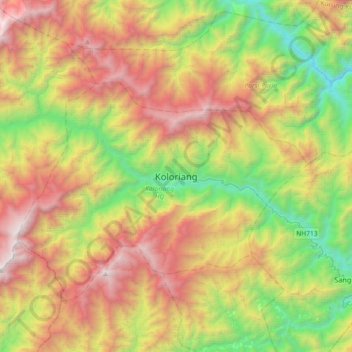
Nom : Carte topographique Koloriang, altitude, relief.
Altitude moyenne : 1’791 m
Altitude minimum : 498 m
Altitude maximum : 3’508 m
Faire un don
Équipez-vous pour votre prochaine aventure :
En tant que Partenaire Amazon, ce site perçoit une commission sur les achats éligibles sans surcoût pour vous.