
Carte topographique Culebra
Carte interactive
Cliquez sur la carte pour afficher l’altitude.
Culebra
Culebra is characterized by an irregular topography resulting in a long intricate shoreline. The island is approximately 7 by 5 miles (11 by 8 km). The coast is marked by cliffs, sandy coral beaches and mangrove forests. Inland, the tallest point on the island is Mount Resaca, with an elevation of 636 ft (193.9 m), followed by Balcón Hill, with an elevation of 545 ft (166.1 m).
À propos de cette carte
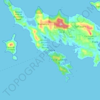
Nom : Carte topographique Culebra, altitude, relief.
Lieu : Culebra, Puerto Rico, 00775-0969, United States (18.26305 -65.34010 18.34305 -65.26010)
Altitude moyenne : 16 m
Altitude minimum : -3 m
Altitude maximum : 188 m
Autres cartes topographiques
Cliquez sur une carte pour visualiser sa topographie, son altitude et son relief.
Isla de Culebra
United States > Puerto Rico > Culebra > Culebra
Culebra is characterized by an irregular topography resulting in a long intricate shoreline. The island is approximately 7 by 5 miles (11 by 8 km). The coast is marked by cliffs, sandy coral beaches and mangrove forests. Inland, the tallest point on the island is Mount Resaca, with an elevation of 636 feet…
Altitude moyenne : 11 m