
Carte topographique Punalur
Carte interactive
Cliquez sur la carte pour afficher l’altitude.
À propos de cette carte
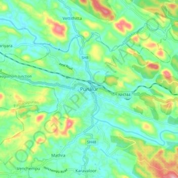
Nom : Carte topographique Punalur, altitude, relief.
Lieu : Punalur, Kollam District, Kerala, 691305, India (8.97746 76.88648 9.05746 76.96648)
Altitude moyenne : 63 m
Altitude minimum : 13 m
Altitude maximum : 182 m
Punalur has an average elevation of 56 metres (184 ft). Many tourists have visited scenic spots along the Kallada River. The Palaruvi Falls is 35 kilometres (22 mi) from Punalur. The first planned eco-tourism project in Kerala is only 20 kilometres (12 mi) from Punalur on NH 744 towards Sengottai.
Autres cartes topographiques
Cliquez sur une carte pour visualiser sa topographie, son altitude et son relief.
Achankovil
Achankovil, Punalur, Kollam District, Kerala, India
Altitude moyenne : 177 m
Kulathupuzha
Kulathupuzha, Punalur, Kollam District, Kerala, 691310, India
Altitude moyenne : 150 m
Thenmala Dam
India > Kerala > Punalur > Thenmala
Thenmala Dam, Thenmala, Punalur, Kollam, Kerala, India
Altitude moyenne : 155 m
Vellor Ela Thodu
Vellor Ela Thodu, Punalur, Kollam, Kerala, 691548, India
Altitude moyenne : 77 m
Kulathupuzha
Kulathupuzha, Punalur, Kollam, Kerala, 691310, India
Altitude moyenne : 226 m
Shendurney WLS
India > Kerala > Punalur > Thenmala
Shendurney WLS, Thenmala, Punalur, Kollam, Kerala, India
Altitude moyenne : 367 m