
Carte topographique Roosevelt
Carte interactive
Cliquez sur la carte pour afficher l’altitude.
À propos de cette carte
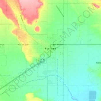
Nom : Carte topographique Roosevelt, altitude, relief.
Lieu : Roosevelt, Duchesne County, Utah, 84066, United States (40.26228 -110.06801 40.33372 -109.97657)
Altitude moyenne : 1’553 m
Altitude minimum : 1’513 m
Altitude maximum : 1’645 m
Roosevelt is situated on U.S. Route 40 in the northeast corner of the state, south of the Uinta Mountains, at an elevation of 5,250 feet (1,600 m). The town was incorporated at a mass meeting of 44 citizens on 21 February 1913. From 1906 to 1914 Roosevelt was in Wasatch County, but in 1914 Duchesne County was formed from part of Wasatch County, and, as the largest town in the county, Roosevelt anticipated becoming the county seat. However, when the total county-wide vote came in, the seat went to Duchesne.
Autres cartes topographiques
Cliquez sur une carte pour visualiser sa topographie, son altitude et son relief.
Fruitland
United States > Utah > Duchesne County
Fruitland, Duchesne County, Utah, 84027, United States
Altitude moyenne : 2’028 m
Starvation State Park
United States > Utah > Duchesne County
Starvation State Park, Duchesne County, Utah, United States
Altitude moyenne : 1’786 m
High Uintas Wilderness
United States > Utah > Duchesne County
High Uintas Wilderness, Duchesne County, Utah, United States
Altitude moyenne : 2’919 m
Kings Peak
United States > Utah > Duchesne County
Kings Peak, Duchesne County, Utah, United States
Altitude moyenne : 3’743 m