
Carte topographique Bald Knob
Carte interactive
Cliquez sur la carte pour afficher l’altitude.
À propos de cette carte
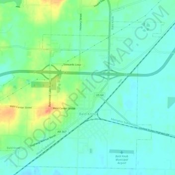
Nom : Carte topographique Bald Knob, altitude, relief.
Lieu : Bald Knob, White County, Arkansas, United States (35.29619 -91.59778 35.33637 -91.54464)
Altitude moyenne : 73 m
Altitude minimum : 59 m
Altitude maximum : 106 m
Autres cartes topographiques
Cliquez sur une carte pour visualiser sa topographie, son altitude et son relief.
Doniphan
United States > Arkansas > White County
Doniphan, White County, Arkansas, 72068, United States
Altitude moyenne : 69 m
Garner
United States > Arkansas > White County
Garner, White County, Arkansas, 72143, United States
Altitude moyenne : 68 m
Romance
United States > Arkansas > White County
Romance, White County, Arkansas, 72136, United States
Altitude moyenne : 192 m
Russell
United States > Arkansas > White County
Russell, White County, Arkansas, 72139, United States
Altitude moyenne : 79 m