
Carte topographique Hinton
Carte interactive
Cliquez sur la carte pour afficher l’altitude.
À propos de cette carte
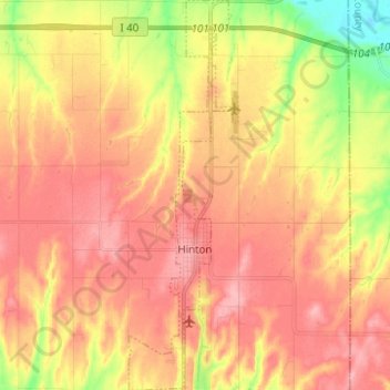
Nom : Carte topographique Hinton, altitude, relief.
Lieu : Hinton, Caddo County, Oklahoma, United States (35.43482 -98.37679 35.53626 -98.34174)
Altitude moyenne : 482 m
Altitude minimum : 416 m
Altitude maximum : 523 m
Hinton is located in northeastern Caddo County at an elevation of 1,676 feet (511 m). The town limits extend north from the settled part of town 4 miles (6 km) along U.S. Route 281 to Interstate 40 at Exit 101, from which it is 49 miles (79 km) east to the center of Oklahoma City.
Autres cartes topographiques
Cliquez sur une carte pour visualiser sa topographie, son altitude et son relief.
Bridgeport
United States > Oklahoma > Caddo County
Bridgeport, Caddo County, Oklahoma, United States
Altitude moyenne : 444 m
Boone
United States > Oklahoma > Caddo County
Boone, Caddo County, Oklahoma, United States
Altitude moyenne : 426 m
Apache
United States > Oklahoma > Caddo County
Apache, Caddo County, Oklahoma, United States
Altitude moyenne : 390 m
Carnegie
United States > Oklahoma > Caddo County
Carnegie, Caddo County, Oklahoma, 73015, United States
Altitude moyenne : 410 m
Scott
United States > Oklahoma > Caddo County
Scott, Caddo County, Oklahoma, United States
Altitude moyenne : 483 m
Anadarko
United States > Oklahoma > Caddo County
Anadarko, Caddo County, Oklahoma, 73005, United States
Altitude moyenne : 369 m
Washita
United States > Oklahoma > Caddo County > Washita
Washita, Caddo County, Oklahoma, United States
Altitude moyenne : 382 m