
Carte topographique Fayetteville
Carte interactive
Cliquez sur la carte pour afficher l’altitude.
À propos de cette carte
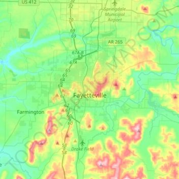
Nom : Carte topographique Fayetteville, altitude, relief.
Lieu : Fayetteville, Washington County, Arkansas, United States (35.98936 -94.29778 36.14893 -94.02671)
Altitude moyenne : 401 m
Altitude minimum : 325 m
Altitude maximum : 581 m
...yet I venture the assertion that nowhere in said country—or for that matter, in any part of the state—could be found a lovelier elevation, or a lovelier grove of graceful oaks, or a more commanding view, or, in fine, a spot better suited and adapted for the purposes designated than the one chosen for said University [of Arkansas] site and farm.
Autres cartes topographiques
Cliquez sur une carte pour visualiser sa topographie, son altitude et son relief.
Prairie Grove
United States > Arkansas > Washington County
Prairie Grove, Washington County, Arkansas, 72753, United States
Altitude moyenne : 356 m
Springdale
United States > Arkansas > Washington County > Springdale
Springdale, Washington County, Arkansas, 72764, United States
Altitude moyenne : 388 m
Springdale
United States > Arkansas > Washington County
Springdale, Washington County, Arkansas, United States
Altitude moyenne : 398 m