Géolocaliser

Carte topographique Dufftown

Cliquez sur la carte pour afficher l’altitude.

À propos de cette carte

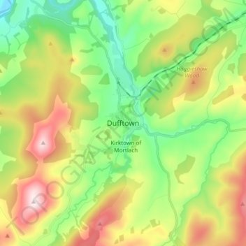
Nom : Carte topographique Dufftown, altitude, relief.

Lieu : Dufftown, Moray, Scotland, AB55 4AD, United Kingdom (57.40490 -3.16835 57.48490 -3.08835)

Altitude moyenne : 268 m

Altitude minimum : 79 m

Altitude maximum : 567 m

Autres cartes topographiques

Cliquez sur une carte pour visualiser sa topographie, son altitude et son relief.

Fochabers

United Kingdom > Scotland > Moray

The present village owes its existence to Alexander Gordon, 4th Duke of Gordon (1743–1827). During the late eighteenth century, during the Scottish Enlightenment, it was fashionable for landowners to found new towns and villages; these can be recognised all over Scotland, because unlike their predecessors…

Altitude moyenne : 59 m

Findhorn Bay

United Kingdom > Scotland > Moray > Findhorn

Altitude moyenne : 3 m

Auchindoun Castle

United Kingdom > Scotland > Moray > Dufftown

Altitude moyenne : 274 m

River Lossie

United Kingdom > Scotland > Moray

Altitude moyenne : 135 m

River Deveron

United Kingdom > Scotland > Moray

Altitude moyenne : 167 m

River Isla

United Kingdom > Scotland > Moray > Keith

Altitude moyenne : 188 m

Équipez-vous pour votre prochaine aventure :

🍽️Popotes de camping - Ustensiles légers pour repas en bivouac
🔥Réchaud de camping compact - Préparez vos repas chauds partout, même par vent fort
🐕Harnais de randonnée pour chien - Partagez vos aventures avec votre compagnon à quatre pattes
🔥Réchauds de camping - Réchauds compacts pour cuisine outdoor
🧳Sacs de transport outdoor - Organisation du matériel

En tant que Partenaire Amazon, ce site perçoit une commission sur les achats éligibles sans surcoût pour vous.