
Carte topographique La Luz
Carte interactive
Cliquez sur la carte pour afficher l’altitude.
À propos de cette carte
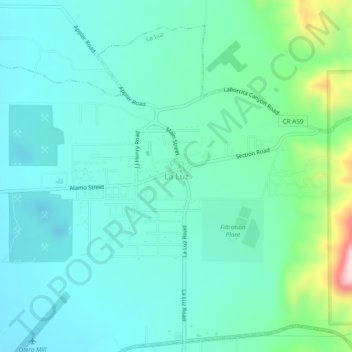
Nom : Carte topographique La Luz, altitude, relief.
Lieu : La Luz, Otero County, New Mexico, 88337, United States (32.95711 -105.96352 32.99711 -105.92352)
Altitude moyenne : 1’452 m
Altitude minimum : 1’380 m
Altitude maximum : 1’741 m
The largest employer in the surrounding area is Holloman Air Force Base. La Luz itself is largely residential and agricultural in land use but a small market is located on the state maintained road that connects the village to Highway 70. La Luz has long been known for the many fruits that are grown in the area including figs, apricots, plums and peaches. Apples, cherries, and pears are grown in the higher elevations in the canyon areas to the east of the village. The surrounding area also has a number of vineyards and pistachio groves. A number of artists also reside in the area.
Autres cartes topographiques
Cliquez sur une carte pour visualiser sa topographie, son altitude et son relief.
Alamorosa
United States > New Mexico > Otero County
Alamorosa, Otero County, New Mexico, 88337, United States
Altitude moyenne : 1’365 m
Cloudcroft
United States > New Mexico > Otero County
Cloudcroft, Otero County, New Mexico, United States
Altitude moyenne : 2’643 m
Orogrande
United States > New Mexico > Otero County
Orogrande, Otero County, New Mexico, 88342, United States
Altitude moyenne : 1’285 m
Weed
United States > New Mexico > Otero County
Weed, Otero County, New Mexico, 88354, United States
Altitude moyenne : 2’212 m
Timberon
United States > New Mexico > Otero County
Timberon, Otero County, New Mexico, 88350, United States
Altitude moyenne : 2’181 m
Apache
United States > New Mexico > Otero County
Apache, Otero County, New Mexico, United States
Altitude moyenne : 1’957 m
Cloudcroft
United States > New Mexico > Otero County > Cloudcroft
Cloudcroft, Otero County, New Mexico, 88317, United States
Altitude moyenne : 2’636 m
White Sands National Park
United States > New Mexico > Otero County
White Sands National Park, Otero County, New Mexico, United States
Altitude moyenne : 1’214 m
Alamogordo
United States > New Mexico > Otero County
Alamogordo, Otero County, New Mexico, 88310, United States
Altitude moyenne : 1’644 m
Alamogordo
United States > New Mexico > Otero County
Alamogordo, Otero County, New Mexico, United States
Altitude moyenne : 1’515 m
La Luz
United States > New Mexico > Otero County
La Luz, Otero County, New Mexico, 88337, United States
Altitude moyenne : 1’493 m
Mayhill
United States > New Mexico > Otero County
Mayhill, Otero County, New Mexico, United States
Altitude moyenne : 2’104 m
High Rolls
United States > New Mexico > Otero County
High Rolls, Otero County, New Mexico, 88325, United States
Altitude moyenne : 2’036 m
Sacramento
United States > New Mexico > Otero County
Sacramento, Otero County, New Mexico, 88347, United States
Altitude moyenne : 2’320 m