
Carte topographique Thoreau
Carte interactive
Cliquez sur la carte pour afficher l’altitude.
À propos de cette carte
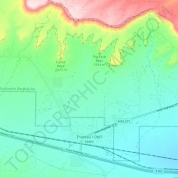
Nom : Carte topographique Thoreau, altitude, relief.
Lieu : Thoreau, McKinley County, New Mexico, 87323, United States (35.38735 -108.27384 35.45973 -108.18253)
Altitude moyenne : 2’253 m
Altitude minimum : 2’138 m
Altitude maximum : 2’591 m
Thoreau is located at an altitude of approximately 2,200 meters (7,200 feet) above sea level, and 8 kilometers (5.0 mi) east of the continental divide. Thoreau is located in a broad valley beneath a large escarpment of Entrada sandstone, which marks the southern boundary of the Colorado Plateau to the north. Mount Powell and Castle Rock are landmarks along this escarpment adjacent to Thoreau. The Zuñi Mountains are to the south.
Autres cartes topographiques
Cliquez sur une carte pour visualiser sa topographie, son altitude et son relief.
Gallup
United States > New Mexico > McKinley County
Gallup, McKinley County, New Mexico, 87301, United States
Altitude moyenne : 2’067 m
Zuni Pueblo
United States > New Mexico > McKinley County
Zuni Pueblo, McKinley County, New Mexico, 87327, United States
Altitude moyenne : 1’931 m
Littlewater
United States > New Mexico > McKinley County
Littlewater, Eastern Navajo Agency, McKinley County, New Mexico, United States
Altitude moyenne : 2’082 m
Crownpoint
United States > New Mexico > McKinley County
Crownpoint, Eastern Navajo Agency, McKinley County, New Mexico, 87313, United States
Altitude moyenne : 2’099 m
Pinedale
United States > New Mexico > McKinley County
Pinedale, Eastern Navajo Agency, McKinley County, New Mexico, United States
Altitude moyenne : 2’154 m
Navajo
United States > New Mexico > McKinley County
Navajo, Fort Defiance Agency, McKinley County, New Mexico, 87328, United States
Altitude moyenne : 2’203 m
Prewitt Lake
United States > New Mexico > McKinley County
Prewitt Lake, McKinley County, New Mexico, United States
Altitude moyenne : 2’393 m
Nahodishgish
United States > New Mexico > McKinley County
Nahodishgish, Eastern Navajo Agency, McKinley County, New Mexico, United States
Altitude moyenne : 2’061 m
Continental Divide
United States > New Mexico > McKinley County
Continental Divide, McKinley County, New Mexico, 87312, United States
Altitude moyenne : 2’221 m
Ramah
United States > New Mexico > McKinley County
Ramah, Eastern Navajo Agency, McKinley County, New Mexico, United States
Altitude moyenne : 2’184 m
Eastern Navajo Agency
United States > New Mexico > McKinley County
Eastern Navajo Agency, McKinley County, New Mexico, United States
Altitude moyenne : 2’005 m
Pueblo Pintado
United States > New Mexico > McKinley County > Pueblo Pintado
Pueblo Pintado, Navajo Route 7008, Pueblo Pintado, Eastern Navajo Agency, McKinley County, New Mexico, United States
Altitude moyenne : 1’981 m
Smith Lake
United States > New Mexico > McKinley County
Smith Lake, Eastern Navajo Agency, McKinley County, New Mexico, United States
Altitude moyenne : 2’221 m
Tinian
United States > New Mexico > McKinley County
Tinian, Eastern Navajo Agency, McKinley County, New Mexico, United States
Altitude moyenne : 2’014 m