
Carte topographique Big Bend National Park
Carte interactive
Cliquez sur la carte pour afficher l’altitude.
À propos de cette carte
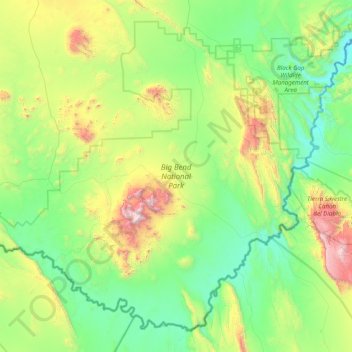
Nom : Carte topographique Big Bend National Park, altitude, relief.
Altitude moyenne : 934 m
Altitude minimum : 490 m
Altitude maximum : 2’330 m
Big Bend National Park is an American national park located in West Texas, bordering Mexico. The park has national significance as the largest protected area of Chihuahuan Desert topography and ecology in the United States, and was named after a large bend in the Rio Grande/Río Bravo. The park protects more than 1,200 species of plants, more than 450 species of birds, 56 species of reptiles, and 75 species of mammals. Additional park activities include scenic drives, programs led by Big Bend park rangers, and stargazing.
Autres cartes topographiques
Cliquez sur une carte pour visualiser sa topographie, son altitude et son relief.
Big Bend National Park
United States > Texas > Brewster County
Big Bend National Park, Brewster County, Texas, 79834, United States
Altitude moyenne : 934 m
Santiago Peak
United States > Texas > Brewster County
Santiago Peak, Brewster County, Texas, United States
Altitude moyenne : 1’525 m
Alpine
United States > Texas > Brewster County
Alpine, Brewster County, Texas, United States
Altitude moyenne : 1’373 m