
Carte topographique Bayview
Carte interactive
Cliquez sur la carte pour afficher l’altitude.
À propos de cette carte
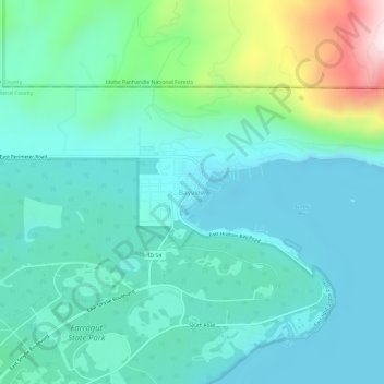
Nom : Carte topographique Bayview, altitude, relief.
Lieu : Bayview, Kootenai County, Idaho, United States (47.96033 -116.58043 48.00033 -116.54043)
Altitude moyenne : 733 m
Altitude minimum : 616 m
Altitude maximum : 1’195 m
Bayview is an unincorporated community in the northwest United States, located in Kootenai County, Idaho, north of Coeur d'Alene. On the southwest shore of Lake Pend Oreille, Bayview is seven miles (11 km) east-northeast of Athol. The community is served by State Highway 54 and a post office with ZIP code 83803; its approximate elevation is 2,100 feet (640 m) above sea level. Nearby is Farragut State Park, formerly the Farragut Naval Training Station, a major training facility during World War II.
Autres cartes topographiques
Cliquez sur une carte pour visualiser sa topographie, son altitude et son relief.
Coeur d'Alene
United States > Idaho > Kootenai County
Coeur d'Alene, Kootenai County, Idaho, United States
Altitude moyenne : 719 m
Athol
United States > Idaho > Kootenai County
Athol, Kootenai County, Idaho, United States
Altitude moyenne : 733 m
Post Falls
United States > Idaho > Kootenai County
Post Falls, Kootenai County, Idaho, 83854, United States
Altitude moyenne : 710 m
Hayden
United States > Idaho > Kootenai County
Hayden, Kootenai County, Idaho, 83835, United States
Altitude moyenne : 717 m
Rathdrum
United States > Idaho > Kootenai County
Rathdrum, Kootenai County, Idaho, 83858, United States
Altitude moyenne : 701 m