
Carte topographique Föching
Cliquez sur la carte pour afficher l’altitude.
À propos de cette carte
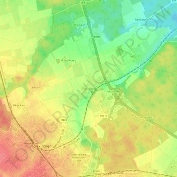
Nom : Carte topographique Föching, altitude, relief.
Altitude moyenne : 669 m
Altitude minimum : 632 m
Altitude maximum : 699 m
Autres cartes topographiques
Cliquez sur une carte pour visualiser sa topographie, son altitude et son relief.
Hackensee
Deutschland > Bayern > Landkreis Miesbach > Holzkirchen > Kleinhartpenning
Altitude moyenne : 725 m