
Carte topographique Mount Banahaw
Carte interactive
Cliquez sur la carte pour afficher l’altitude.
À propos de cette carte
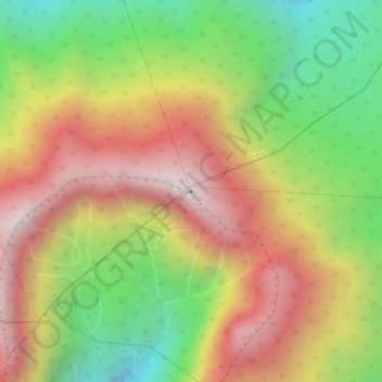
Nom : Carte topographique Mount Banahaw, altitude, relief.
Lieu : Mount Banahaw, Tayabas, Calabarzon, 4327, Philippines (14.06748 121.49227 14.06758 121.49237)
Altitude moyenne : 1’730 m
Altitude minimum : 1’261 m
Altitude maximum : 2’145 m
The andesitic Banahaw volcanic complex is composed of several stratovolcanoes with Mount Banahaw, the largest with a maximum elevation of 2,170 metres (7,119 ft) above mean sea level. The summit is topped by a 1.5 by 3.5 kilometres (0.93 mi × 2.17 mi) and 210 metres (690 ft) deep crater that is breached on the southern rim believed to have been caused by the 1730 eruption. Prior to 1730, a lake occupied the summit crater of Mount Banahaw. The resulting flood destroyed the town of Sariaya, Quezon located below the mountain.[7]
Autres cartes topographiques
Cliquez sur une carte pour visualiser sa topographie, son altitude et son relief.