
Carte topographique Chesterville
Carte interactive
Cliquez sur la carte pour afficher l’altitude.
À propos de cette carte
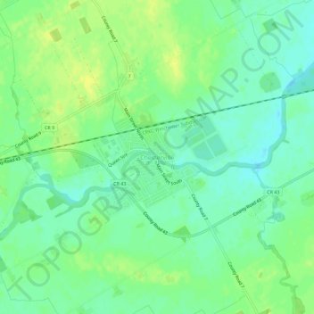
Nom : Carte topographique Chesterville, altitude, relief.
Altitude moyenne : 74 m
Altitude minimum : 65 m
Altitude maximum : 84 m
Autres cartes topographiques
Cliquez sur une carte pour visualiser sa topographie, son altitude et son relief.
Ormond
Canada > Ontario > Stormont, Dundas and Glengarry Counties > North Dundas
Ormond, North Dundas, Stormont, Dundas and Glengarry Counties, Eastern Ontario, Ontario, Canada
Altitude moyenne : 77 m
Timmins Drain
Canada > Ontario > Stormont, Dundas and Glengarry Counties > North Dundas
Timmins Drain, North Dundas, Stormont, Dundas and Glengarry Counties, Eastern Ontario, Ontario, Canada
Altitude moyenne : 72 m
Winchester
Canada > Ontario > Stormont, Dundas and Glengarry Counties > North Dundas
Winchester, North Dundas, Stormont, Dundas and Glengarry Counties, Eastern Ontario, Ontario, K0C 2K0, Canada
Altitude moyenne : 76 m
Hallville
Canada > Ontario > Stormont, Dundas and Glengarry Counties > North Dundas
Hallville, North Dundas, Stormont, Dundas and Glengarry Counties, Eastern Ontario, Ontario, Canada
Altitude moyenne : 91 m