
Faire un don
Équipez-vous pour votre prochaine aventure :
En tant que Partenaire Amazon, ce site perçoit une commission sur les achats éligibles sans surcoût pour vous.
Carte topographique La Honda
Cliquez sur la carte pour afficher l’altitude.
Faire un don
Équipez-vous pour votre prochaine aventure :
En tant que Partenaire Amazon, ce site perçoit une commission sur les achats éligibles sans surcoût pour vous.
À propos de cette carte
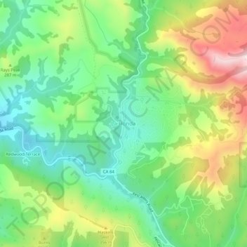
Nom : Carte topographique La Honda, altitude, relief.
Altitude moyenne : 246 m
Altitude minimum : 71 m
Altitude maximum : 541 m
Faire un don
Équipez-vous pour votre prochaine aventure :
En tant que Partenaire Amazon, ce site perçoit une commission sur les achats éligibles sans surcoût pour vous.
Autres cartes topographiques
Cliquez sur une carte pour visualiser sa topographie, son altitude et son relief.
San Bruno
United States > California > San Mateo County
According to the United States Census Bureau, the city has a total area of 5.5 square miles (14 km2), all of it land. The city spreads from the mostly flat lowlands near San Francisco Bay into the foothills of the Santa Cruz Mountains, which rise to more than 600 feet (180 m) above sea level in Crestmoor and…
Altitude moyenne : 106 m
Daly City
United States > California > San Mateo County
Several golf courses are located within or straddle the border with San Francisco. The Olympic Club has hosted the USGA U.S. Open five times, most recently in 2012, and will host both the 2028 PGA Championship and the 2032 Ryder Cup. The private San Francisco Golf Club and Lake Merced Golf Club have part or…
Altitude moyenne : 75 m
Faire un don
Équipez-vous pour votre prochaine aventure :
En tant que Partenaire Amazon, ce site perçoit une commission sur les achats éligibles sans surcoût pour vous.
Bayshore Heights Park
United States > California > San Mateo County > Daly City
Altitude moyenne : 84 m
Faire un don
Équipez-vous pour votre prochaine aventure :
En tant que Partenaire Amazon, ce site perçoit une commission sur les achats éligibles sans surcoût pour vous.
Montara
United States > California > San Mateo County > Montara
The rare and endangered species Hickman's potentilla occurs at the northern extremity of Montara on the slopes above Martini Creek at elevations ranging from 32 to 410 ft (9.8 to 125.0 m).
Altitude moyenne : 66 m
Faire un don
Équipez-vous pour votre prochaine aventure :
En tant que Partenaire Amazon, ce site perçoit une commission sur les achats éligibles sans surcoût pour vous.
Red Morton Community Park
United States > California > San Mateo County > Redwood City
Altitude moyenne : 18 m
Faire un don
Équipez-vous pour votre prochaine aventure :
En tant que Partenaire Amazon, ce site perçoit une commission sur les achats éligibles sans surcoût pour vous.
Hillsborough
United States > California > San Mateo County
According to the United States Census Bureau, the town has a total area of 6.2 square miles (16 km2), all of it land. The area's considerably winding, hilly topography, and impossibility of a grid layout make Hillsborough notoriously challenging to navigate. Many lots include fairly steep slopes, particularly…
Altitude moyenne : 100 m
Faire un don
Équipez-vous pour votre prochaine aventure :
En tant que Partenaire Amazon, ce site perçoit une commission sur les achats éligibles sans surcoût pour vous.
Faire un don
Équipez-vous pour votre prochaine aventure :
En tant que Partenaire Amazon, ce site perçoit une commission sur les achats éligibles sans surcoût pour vous.
Faire un don
Équipez-vous pour votre prochaine aventure :
En tant que Partenaire Amazon, ce site perçoit une commission sur les achats éligibles sans surcoût pour vous.
Faire un don
Équipez-vous pour votre prochaine aventure :
En tant que Partenaire Amazon, ce site perçoit une commission sur les achats éligibles sans surcoût pour vous.
Faire un don
Équipez-vous pour votre prochaine aventure :
En tant que Partenaire Amazon, ce site perçoit une commission sur les achats éligibles sans surcoût pour vous.
Faire un don
Équipez-vous pour votre prochaine aventure :
En tant que Partenaire Amazon, ce site perçoit une commission sur les achats éligibles sans surcoût pour vous.
West Menlo Park
United States > California > San Mateo County > West Menlo Park
Altitude moyenne : 51 m
Faire un don
Équipez-vous pour votre prochaine aventure :
En tant que Partenaire Amazon, ce site perçoit une commission sur les achats éligibles sans surcoût pour vous.
Daly City
United States > California > San Mateo County
Several golf courses are located within or straddle the border with San Francisco. The Olympic Club has hosted the USGA U.S. Open five times, most recently in 2012, and will host both the 2028 PGA Championship and the 2032 Ryder Cup. The private San Francisco Golf Club and Lake Merced Golf Club have part or…
Altitude moyenne : 75 m
Faire un don
Équipez-vous pour votre prochaine aventure :
En tant que Partenaire Amazon, ce site perçoit une commission sur les achats éligibles sans surcoût pour vous.
San Bruno
United States > California > San Mateo County
According to the United States Census Bureau, the city has a total area of 5.5 square miles (14 km2), all of it land. The city spreads from the mostly flat lowlands near San Francisco Bay into the foothills of the Santa Cruz Mountains, which rise to more than 600 feet (180 m) above sea level in Crestmoor and…
Altitude moyenne : 53 m
Faire un don
Équipez-vous pour votre prochaine aventure :
En tant que Partenaire Amazon, ce site perçoit une commission sur les achats éligibles sans surcoût pour vous.
Faire un don
Équipez-vous pour votre prochaine aventure :
En tant que Partenaire Amazon, ce site perçoit une commission sur les achats éligibles sans surcoût pour vous.
Faire un don
Équipez-vous pour votre prochaine aventure :
En tant que Partenaire Amazon, ce site perçoit une commission sur les achats éligibles sans surcoût pour vous.
Faire un don
Équipez-vous pour votre prochaine aventure :
En tant que Partenaire Amazon, ce site perçoit une commission sur les achats éligibles sans surcoût pour vous.
Hillsborough
United States > California > San Mateo County
According to the United States Census Bureau, the town has a total area of 6.2 square miles (16 km2), all of it land. The area's considerably winding, hilly topography, and impossibility of a grid layout make Hillsborough notoriously challenging to navigate. Many lots include fairly steep slopes, particularly…
Altitude moyenne : 100 m
Montara
United States > California > San Mateo County > Montara
The rare and endangered species Hickman's potentilla occurs at the northern extremity of Montara on the slopes above Martini Creek at elevations ranging from 32 to 410 ft (9.8 to 125.0 m).
Altitude moyenne : 169 m
Faire un don
Équipez-vous pour votre prochaine aventure :
En tant que Partenaire Amazon, ce site perçoit une commission sur les achats éligibles sans surcoût pour vous.
San Bruno
United States > California > San Mateo County
According to the United States Census Bureau, the city has a total area of 5.5 square miles (14 km2), all of it land. The city spreads from the mostly flat lowlands near San Francisco Bay into the foothills of the Santa Cruz Mountains, which rise to more than 600 feet (180 m) above sea level in Crestmoor and…
Altitude moyenne : 106 m
Faire un don
Équipez-vous pour votre prochaine aventure :
En tant que Partenaire Amazon, ce site perçoit une commission sur les achats éligibles sans surcoût pour vous.